Slide 1 of 8
Slide 1 - Community Data in DRR Planning
- Tanzania Community Ground Mapping
- Disaster Risk Visualization
- Flood, Earthquake, Fire Icons
- Tanzania Flag Overlay
- Diverse People in DRR
- Spatial Data & Resilience Charts
Generated from prompt:
Table of Contents THE ROLE OF COMMUNITY DATA IN STRENGTHENING DISASTER RISK REDUCTION PLANNING.2 1.0 CHAPTER ONE: INTRODUCTION2 1.1 Background of the Study2 1.2 Problem Statement.3 1.3 General Objective.4 1.4 Research Questions4 1.5 Significance of the Study.5 1.6 Relevance of the Study to Urban Planning5 1.7 Scope of the Study5 THE ROLE OF COMMUNITY DATA IN STRENGTHENING DISASTER RISK REDUCTION PLANNING. 1.0 CHAPTER ONE: INTRODUCTION 1.1 Background of the Study Disaster Risk Reduction (DRR) is a comprehensive approach aimed at identifying, assessing, and minimizing the risks associated with natural and human induced hazards. Its primary goal is to reduce vulnerabilities and enhance the resilience of societies by integrating risk reduction into sustainable development strategies and humanitarian actions (Zeeshan et al., 2019). Over recent decades, the DRR approach has evolved from a focus on managing disasters to proactively reducing risks and building resilience, emphasizing the importance of addressing both physical and social dimensions of vulnerability. (Imperiale & Vanclay, 2021; Londoño & Londoño, 2024). The Yokohama Strategy and the Sendai Framework for Disaster Risk Reduction (2015–2030) emphasize proactive, risk-informed planning and call for inclusive, people-centred approaches supported by reliable and timely data (Manyuchi et al., 2025). Community data locally generated information about hazards, vulnerabilities, capacities, and social dynamics has become increasingly recognized as vital for effective DRR. Integrating community data enables a more detailed understanding of local risks, supports tailored interventions, and empowers communities to participate actively in risk reduction planning (Vasileiou et al., 2022; Das & Dutta, 2023; Johnson et al., 2018). The inclusion of local knowledge and data is now widely acknowledged as essential for designing DRR strategies that are responsive to the specific needs and sensitivities of communities, leading to more sustainable and resilient outcomes (Vasileiou et al., 2022; Hermans et al., 2022; Johnson et al., 2018). Despite the recognized value of community data, DRR planning has historically relied on top-down approaches, where governmental authorities and external experts design and implement strategies with limited community involvement. (Londoño & Londoño, 2024; Imperiale & Vanclay, 2021). This command and control model often prioritizes high impact, low frequency hazards and expert driven solutions, sidelining local perspectives and knowledge. (Imperiale & Vanclay, 2021). Such approaches can create persistent vulnerabilities and underdevelopment traps, as they may not address the complex social and cultural factors that shape risk at the community level. (Imperiale & Vanclay, 2021; Londoño & Londoño, 2024). While community data and local knowledge exist in many contexts, mechanisms for their effective integration into formal DRR planning remain weak. Barriers include fragmented data management, lack of participatory methodologies, and insufficient coordination between stakeholders. (Vasileiou et al., 2022; Hermans et al., 2022; Kanbara & Shaw, 2021). Even when community based organizations or data collection efforts are present, their contributions are often underutilized or poorly connected to official planning processes, resulting in a disconnect between local realities and policy interventions. (Mutiarni et al., 2022; Vasileiou et al., 2022; Hermans et al., 2022; Johnson et al., 2018). The failure to effectively integrate community data into DRR planning leads to several negative outcomes. These include the persistence of social vulnerabilities, ineffective or misaligned interventions, delays in response and recovery, and a lack of community ownership over risk reduction measures (Londoño & Londoño, 2024; Imperiale & Vanclay, 2021; Vasileiou et al., 2022). Top down strategies that overlook local data may result in solutions that are not adopted by communities, perpetuate existing risks, and fail to build the resilience needed for sustainable development. (Londoño & Londoño, 2024; Imperiale & Vanclay, 2021; Vasileiou et al., 2022; Rözer et al., 2023). While participatory, data-driven approaches are increasingly advocated to strengthen disaster risk reduction (DRR), the absence of effective mechanisms for integrating community-generated spatial data into formal planning systems continues to limit their practical impact (Vasileiou et al., 2022; Hermans et al., 2022; Londoño & Londoño, 2024; Imperiale & Vanclay, 2021). As a result, there is still a limited understanding of how such community produced spatial knowledge can be incorporated within DRR planning processes. 1.4 Research Gap Although disaster risk reduction (DRR) has been widely studied, the role of community-generated spatial data in strengthening formal DRR planning processes remains insufficiently understood, particularly in developing country contexts (Imperiale & Vanclay, 2021; Vasileiou et al., 2022). Most existing studies emphasize top-down, expert-driven data systems and national-level risk assessments, with limited attention to how locally produced spatial data can be systematically integrated into official planning frameworks (Londoño & Londoño, 2024; Hermans et al., 2022). While participatory approaches and community knowledge are increasingly recognized as valuable, many studies remain largely conceptual or descriptive, offering limited empirical evidence on practical integration mechanisms within formal DRR institutions. Furthermore, studies that examine community data often focus on social vulnerability and qualitative local knowledge, with less emphasis on spatially explicit, community-generated data and its contribution to planning and decision-making processes (Johnson et al., 2018; Das & Dutta, 2023). There is also a limited examination of institutional, technical, and governance barriers that constrain the use of community-generated spatial data within national and local DRR systems, particularly in Sub-Saharan African countries such as Tanzania (Kanbara & Shaw, 2021; Mutiarni et al., 2022). Existing research rarely links community data practices to urban planning frameworks, despite the growing exposure of urban and peri-urban areas to climate-related hazards. In the Tanzanian context, research on DRR has largely focused on hazard impacts, emergency response, and vulnerability assessment, with minimal attention to how community-generated spatial data can enhance proactive risk reduction planning. As a result, there is limited empirical evidence on the contribution of such data to improving planning accuracy, inclusiveness, and resilience outcomes. This study therefore addresses this gap by examining how community-generated spatial data can be integrated into disaster risk reduction planning, identifying existing barriers, and assessing its contribution to decision-making processes, with specific relevance to urban and peri-urban contexts in Tanzania. S/N Author(s) & Year Title of Research Major Findings Specific Research Gap Relevant to This Study 1 Imperiale & Vanclay, 2021 Conceptualizing community resilience and the social dimensions of risk to overcome barriers to disaster risk reduction Emphasizes the importance of community participation and social dimensions in building resilience and effective DRR Focuses largely on conceptual frameworks and lacks empirical analysis on how community-generated spatial data can be integrated into formal DRR planning systems 2 Vasileiou et al., 2022 Integrating local and scientific knowledge in disaster risk reduction: A systematic review Shows that integrating local knowledge improves DRR outcomes and sustainability Does not specifically address mechanisms for integrating community-generated spatial data into official planning and decision-making processes 3 Johnson et al., 2018 Community vulnerability and resilience in disaster risk reduction: an example from India Demonstrates the value of community knowledge in identifying local vulnerabilities and capacities Case-specific and qualitative; lacks spatial data integration and applicability to urban and peri-urban planning contexts 4 Hermans et al., 2022 Exploring the integration of local and scientific knowledge in early warning systems for DRR Highlights benefits of combining local and scientific data in early warning systems Focuses on early warning systems only, without examining broader DRR planning or institutional integration of community-generated spatial data 5 Kanbara & Shaw, 2021 Disaster Risk Reduction Regime in Japan: An analysis in the perspective of open data and governance Shows that open data and governance improve transparency and coordination in DRR Context is a developed country; lacks relevance to developing countries and does not consider community-generated data in informal urban settings 6 Londoño & Londoño, 2024 Persistent vulnerability after disaster risk reduction response Finds that top-down DRR approaches can perpetuate vulnerability if local contexts are ignored Does not explore how community-generated spatial data could reduce persistent vulnerability through improved planning 7 Mutiarni et al., 2022 The resilience community: Strengthening people-centered DRR in Indonesia Demonstrates that people-centered DRR enhances community resilience Lacks spatial analysis and does not assess integration of community-generated data into formal DRR and urban planning frameworks 8 Das & Dutta, 2023 Promoting data science in disaster risk reduction Highlights the potential of data science and alternative data sources for DRR Does not examine institutional barriers or real-world application of community-generated spatial data in planning systems 9 Manyuchi et al., 2025 Leveraging spatial data infrastructure for disaster risk reduction Emphasizes the importance of spatial data infrastructure for effective DRR Focuses on institutional spatial data systems and overlooks the role of community-generated spatial data in urban and peri-urban areas 1.2 Problem Statement. Disaster risk reduction (DRR) in Tanzania continues to depend largely on centralized, top-down data systems that fail to adequately capture localized hazards, socio-economic vulnerabilities, and community capacities. Although community generated data has strong potential to enhance the accuracy, relevance, and inclusiveness of DRR planning, its integration into formal national and local systems remains limited due to institutional rigidity, technical constraints, fragmented data management and governance frameworks that do not prioritize participatory approaches. Yet, weaknesses in risk assessment systems, fragmented data management, and limited mechanisms for incorporating community perspectives into national and regional DRR strategies constrain the effectiveness of these approaches. As a result, vulnerable and marginalized populations particularly residents of informal urban settlements, low-income households, women, and other at risk groups remain disproportionately exposed to climate related hazards and disasters. The exclusion of community knowledge from formal planning processes leads to poorly targeted risk reduction measures, inefficient allocation of resources, and reactive disaster responses. Consequently, disaster preparedness and resilience are weakened, increasing human, economic, and environmental losses and undermining long-term sustainable development in Tanzania. 1.3 General Objective. Main Objective To assess how community generated spatial data can be integrated into disaster risk reduction planning. Specific Objectives. I. To identify the type, source and use of community generated spatial data in disaster risk reduction. II. To investigate institutional barriers in using community generated data into disaster risk reduction plans. III. To measure the contribution of community generated spatial data in disaster risk reduction planning and decision making. 1.4 Research Questions I. What types of community-generated spatial data are used in disaster risk reduction, and what are their sources and applications? II. What institutional barriers limit the integration of community-generated spatial data into disaster risk reduction plans? III. How does community-generated spatial data contribute to disaster risk reduction planning and decision-making? 1.5 Significance of the Study. This study is significant because it highlights the potential of community generated spatial data to improve disaster risk reduction (DRR) planning and decision making. By examining how local level data can be integrated into formal systems, the research provides evidence based insights for policymakers, urban planners, and disaster management authorities. The study also identifies institutional, technical, and governance challenges that limit the use of community data, offering practical recommendations for enhancing data integration and fostering participatory approaches. Ultimately, the findings can contribute to more effective, context specific, and sustainable DRR strategies, particularly in vulnerable and marginalized communities prone to climate related hazards. 1.6 Relevance of the Study to Urban Planning The study is directly relevant to urban planning because disaster risks are closely linked to urban development patterns, population density, and infrastructure planning. Integrating community generated spatial data enables urban planners to identify high risk areas within informal settlements and rapidly urbanizing neighborhoods, design resilient infrastructure and land use plans that consider localized hazards, enhance early warning systems and emergency response strategies at the community level and promote participatory urban governance by incorporating local knowledge into planning processes. By connecting DRR with urban planning, the study supports the creation of safer, more resilient cities and neighborhoods, particularly in contexts like Tanzania where urban growth is rapid and unplanned. 1.7 Scope of the Study This study focuses on the integration of community generated spatial data into disaster risk reduction (DRR) planning in Tanzania, with the aim of linking local level information to national frameworks and strategies. Specifically, the study examines the types and sources of community generated spatial data relevant for DRR, institutional, technical, and governance barriers that hinder the incorporation of community generated data into formal national level DRR planning systems and the contribution of community generated data to enhancing the effectiveness of DRR planning, decision making, and policy formulation at both local and national levels. While the study emphasizes local data collection and community participation, its ultimate objective is to explore mechanisms for integrating this data into national DRR frameworks, ensuring that policies and strategies reflect the realities and vulnerabilities of local communities. The research focuses on urban and peri urban areas prone to climate related hazards, particularly informal settlements, as these contexts provide critical insights into how local data can inform national DRR planning.
Explores integrating community-generated spatial data into Tanzania's top-down DRR planning to address gaps, barriers, and urban resilience in informal settlements. Highlights objectives, research gap
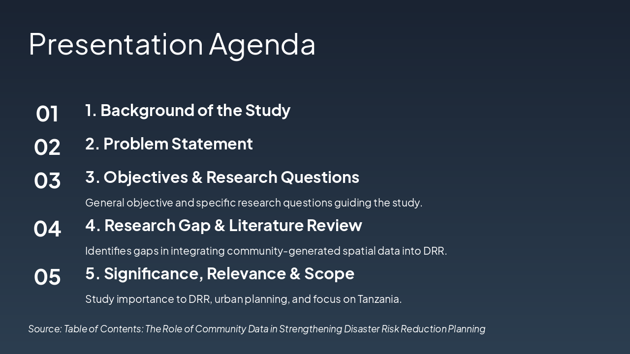
This agenda slide outlines the structure of a presentation on a study related to disaster risk reduction (DRR), starting with background, problem statement, and objectives with research questions. It continues with research gap and literature review, followed by the study's significance, relevance, and scope focused on Tanzania.
General objective and specific research questions guiding the study.
Identifies gaps in integrating community-generated spatial data into DRR.
Study importance to DRR, urban planning, and focus on Tanzania. Source: Table of Contents: The Role of Community Data in Strengthening Disaster Risk Reduction Planning
This section header slide introduces the background of the study (Section 1.1), focusing on the evolution of Disaster Risk Reduction (DRR) toward proactive risk reduction. It highlights the critical role of community data in strengthening DRR planning.
1.1
Evolution of DRR to Proactive Risk Reduction with Community Data
Source: Table of Contents Context
Top-down DRR in Tanzania overlooks local hazards and vulnerabilities, while institutional barriers prevent community data from being integrated into planning. This leads to poor targeting, reactive responses, and higher urban losses.
Source: Chapter 1: Introduction
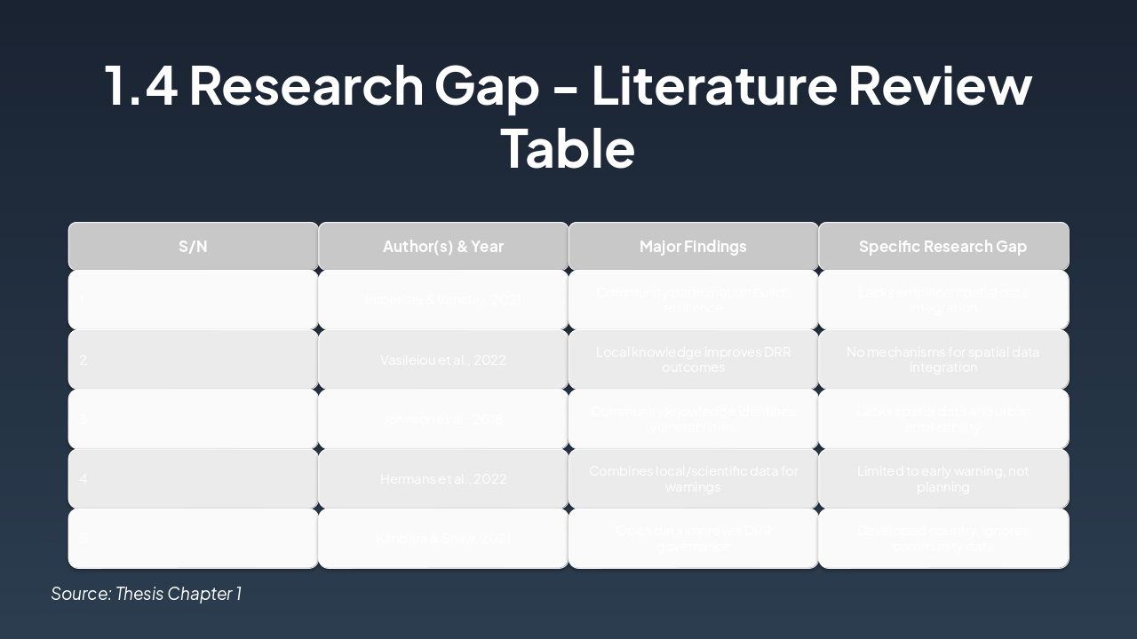
The slide presents a literature review table on research gaps in disaster risk reduction (DRR), highlighting five studies that emphasize community participation, local knowledge, and data integration for building resilience and improving outcomes. Common gaps include the lack of empirical spatial data integration, urban applicability, mechanisms for combining data types, and focus beyond early warnings, often limited by context or scope.
| S/N | Author(s) & Year | Major Findings | Specific Research Gap |
|---|---|---|---|
| 1 | Imperiale & Vanclay, 2021 | Community participation builds resilience | Lacks empirical spatial data integration |
| 2 | Vasileiou et al., 2022 | Local knowledge improves DRR outcomes | No mechanisms for spatial data integration |
| 3 | Johnson et al., 2018 | Community knowledge identifies vulnerabilities | Lacks spatial data and urban applicability |
| 4 | Hermans et al., 2022 | Combines local/scientific data for warnings | Limited to early warning, not planning |
| 5 | Kanbara & Shaw, 2021 | Open data improves DRR governance | Developed country, ignores community data |
Source: Thesis Chapter 1
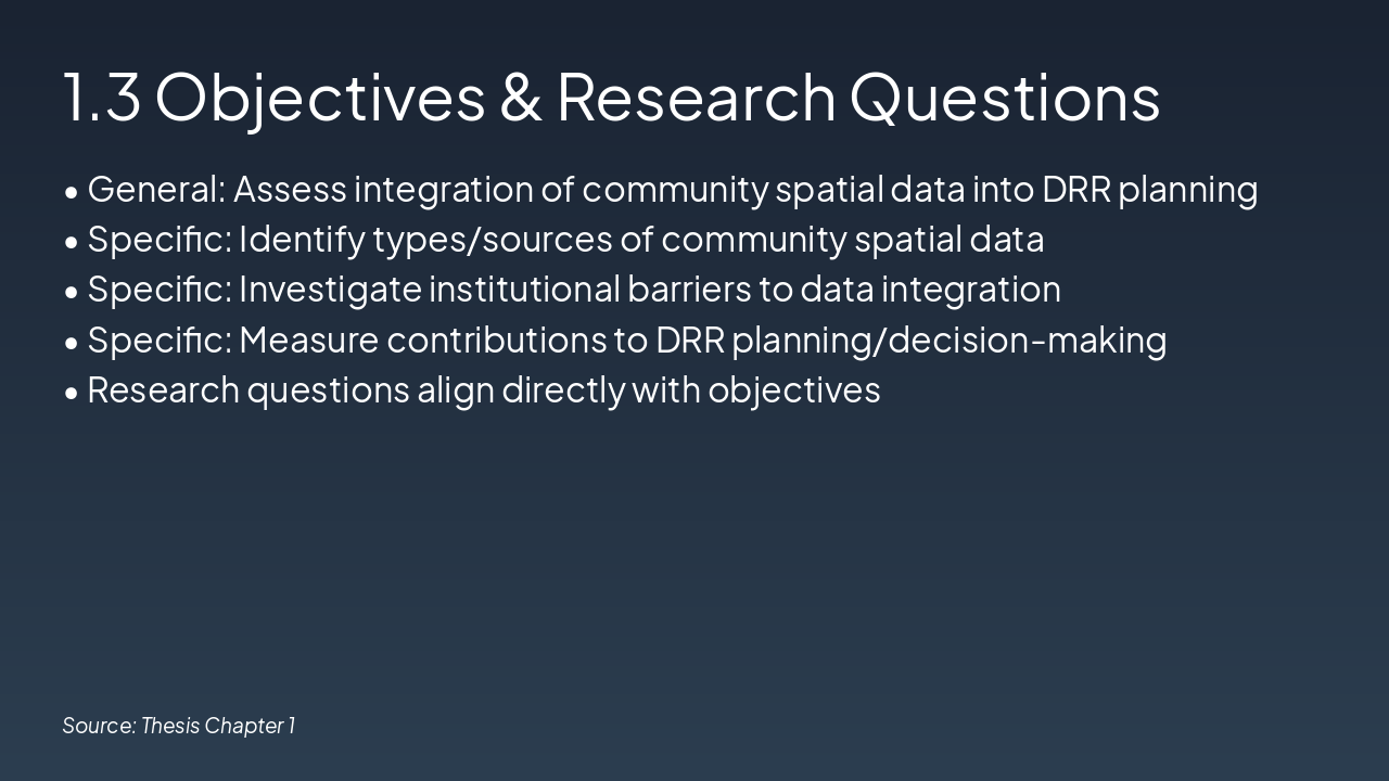
The slide outlines the general objective of assessing the integration of community spatial data into DRR planning, along with specific objectives to identify data types/sources, investigate institutional barriers, and measure contributions to DRR decision-making. It notes that the research questions align directly with these objectives.
Source: Thesis Chapter 1
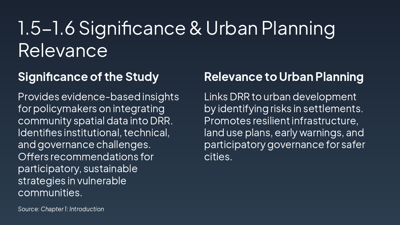
The slide highlights the study's significance in providing evidence-based insights for policymakers on integrating community spatial data into DRR, identifying challenges, and offering recommendations for participatory strategies in vulnerable communities. It also emphasizes relevance to urban planning by linking DRR to development, promoting resilient infrastructure, land use plans, early warnings, and participatory governance for safer cities.
| Significance of the Study | Relevance to Urban Planning |
|---|---|
| Provides evidence-based insights for policymakers on integrating community spatial data into DRR. Identifies institutional, technical, and governance challenges. Offers recommendations for participatory, sustainable strategies in vulnerable communities. | Links DRR to urban development by identifying risks in settlements. Promotes resilient infrastructure, land use plans, early warnings, and participatory governance for safer cities. |
Source: Chapter 1: Introduction
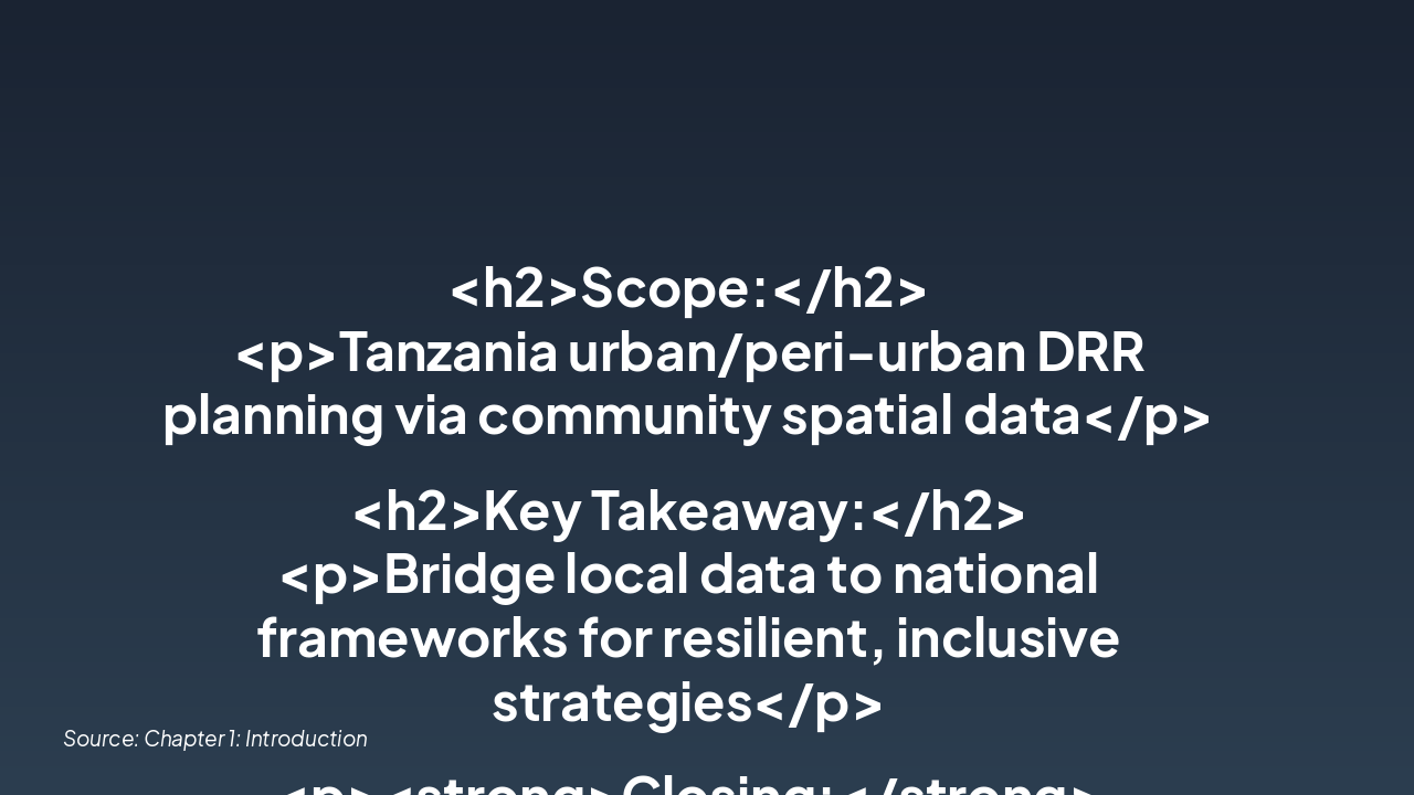
The slide outlines the scope of Tanzania's urban/peri-urban DRR planning using community spatial data. Key takeaways emphasize bridging local data to national frameworks for resilient strategies, with a call to empower communities and integrate data into DRR plans today.
<h2>Scope:</h2> <p>Tanzania urban/peri-urban DRR planning via community spatial data</p>
<h2>Key Takeaway:</h2> <p>Bridge local data to national frameworks for resilient, inclusive strategies</p>
<p><strong>Closing:</strong> Empower communities, strengthen resilience.</p>
<p><strong>Call to Action:</strong> Integrate community data into DRR plans today for safer tomorrows.</p>
Source: Chapter 1: Introduction
Explore thousands of AI-generated presentations for inspiration
Generate professional presentations in seconds with Karaf's AI. Customize this presentation or start from scratch.